Land Surveying Services in Los Angeles
Full-Service Land Surveying for Residential & Commercial Projects
At C.P. Land Surveying, we proudly offer top-tier land surveying services throughout Los Angeles County and surrounding areas. As a family-owned and licensed land surveying company, we are committed to delivering precise, professional, and personable service. Our Los Angeles office is centrally located to serve the greater LA area, providing tailored solutions for residential, commercial, and industrial projects. Whether you need a boundary survey, topographic mapping, or construction staking, our experienced team is here to assist you with the highest standards of quality.
Los Angeles Office
Address
Phone
*Please Call to make an appointment.
Hours
Not sure if we serve your city? We likely do!
Here is a partial list of areas we cover:
- Beverly Hills
- Brentwood
- Hollywood
- Santa Monica
- Glendale
- Pasadena
- Culver City
- Woodland Hills
- West Los Angeles
Contact us today to inquire about services in your area!
Licensed & Insured for Your Peace of Mind
As a licensed and insured land surveying company, we adhere to all local regulations and industry standards, providing you with reliable and professional service every step of the way.
Comprehensive Surveying Services
Residential & Commercial Land Surveying
We offer a wide range of land surveying services tailored to meet the needs of homeowners, engineers, architects, and contractors in the Los Angeles area. Our most requested services include:
- Boundary Surveys: Accurately define property lines and establish true property corners.
- Topographic Surveys: Detailed mapping of land areas, including natural and man-made features.
- ALTA/NSPS Land Title Surveys: Comprehensive surveys for real estate transactions, showing property improvements and significant features.
- Construction Staking: Precise placement of reference points to guide new construction projects.
- Elevation Certificates & LOMA Applications: Essential documentation for properties in flood hazard zones.
View below for a full list of our Services.
Land Surveying Services
A.L.T.A. Surveys
A detailed land parcel map, showing all existing improvements of the property, utilities, and significant observations within the insured estate.
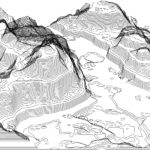
Topographic Map
A detailed record of a land area, giving geographic positions and elevations for both natural and man-made features.
Property Boundary Survey
A process that determines property lines and define true property corners of a parcel of land described in a deed.
Drone / UAV Services
Accurate and dependable drone mapping solutions tailored to your project needs.
Construction Staking
Staking out reference points and markers that will guide the construction of new structures such as roads or buildings.
Elevation Certificates & LOMA Applications
Document needed if your property is or might be in a flood hazard zone as determined by FEMA.
Easement
The right that provides its holder with a non-possessory interest on another person’s land.
Land Subdivision
The act of dividing land into pieces that are easier to sell or otherwise develop, usually via a plat.
Mapping Services
General mapping needs & services pertaining to planimetric surveying and mapping.
Essential Los Angeles Land Resources & Tools
Explore the essential local resources for your land surveying and construction needs in Los Angeles. Whether you’re looking for land records, zoning information, or official benchmarks, these links provide direct access to valuable tools and data. Stay informed and make the most of these resources to ensure your project is successful. Contact us if you need expert guidance or have questions about how these resources can support your land surveying requirements. We’re here to help!